

A topographical knowledge assessment is a formal evaluation of a driver’s ability to read maps, interpret terrain features, and plan routes without relying solely on GPS technology. For anyone pursuing a Private Hire Vehicle (PHV) licence in London, passing the Transport for London (TfL) topographical assessment is a mandatory step. You only receive two attempts before your entire TfL application resets, which makes thorough preparation non-negotiable. Eltconline, based in Forest Gate, London E7, has helped thousands of candidates pass this test by combining structured map-reading training with targeted mock examinations.
What is topographical knowledge assessment and what skills does it test?
The topographical knowledge assessment measures a driver’s proficiency across several interconnected spatial skills, not just the ability to recall street names. The TfL version specifically tests your understanding of London’s geography in ways that a GPS device simply cannot replicate.
The core competencies assessed include:
- Map reading: Interpreting contour lines, terrain symbols, and street hierarchies on standard map formats
- Landmark recognition: Identifying key locations such as hospitals, railway stations, hotels, and public buildings across London
- Route planning: Selecting the shortest practicable route between two points, accounting for one-way systems, restricted roads, and road classifications
- Compass point navigation: Directional questions using compass points to plan and describe routes accurately
- Spatial reasoning: Translating a two-dimensional map into a mental model of a three-dimensional urban environment
- Situational awareness: Anticipating road conditions and street layouts before physically travelling them
Reading a map is both an art and a science. Interpreting complex map symbology demands that drivers accurately decode visual information and apply it to real-world navigation decisions. This cognitive engagement is precisely what separates a competent professional driver from someone who simply follows turn-by-turn instructions.
Pro Tip: Focus your early study sessions on landmark recognition, as this section carries the highest question volume. Once you can confidently place major London landmarks on a mental map, route planning becomes significantly more intuitive.

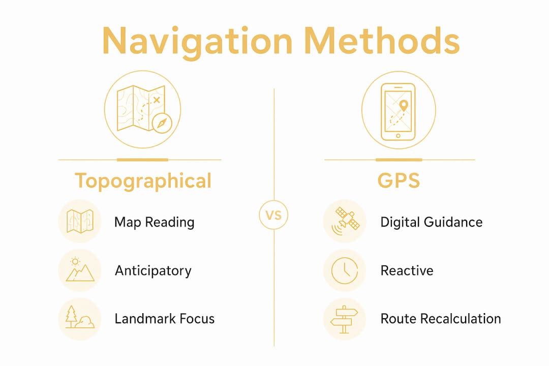
How does topographical assessment differ from GPS-based navigation?
GPS and topographical map reading are not interchangeable skills. They serve fundamentally different cognitive functions, and understanding this distinction explains why TfL requires the assessment in the first place.
| Capability | GPS navigation | Topographical map reading |
|---|---|---|
| Terrain awareness | No elevation or terrain data | Full contour and elevation detail |
| Route decision-making | Reactive, turn-by-turn | Proactive, pre-planned |
| Landmark context | Limited or absent | Comprehensive spatial context |
| Technology dependency | High | None |
| Cognitive engagement | Passive | Active and analytical |
| Failure risk | Signal loss, app errors | None once knowledge is internalised |
GPS excels at pinpointing location but provides no understanding of how the land moves, how streets connect structurally, or why certain routes are more efficient than others. This matters enormously in a city like London, where road closures, events, and congestion require drivers to make rapid, informed decisions without waiting for an app to recalculate.
“Topographic maps show how land moves through contour lines. GPS only shows position.” — Topostreets.com
Topographical knowledge forces drivers to read terrain before travel, building anticipatory rather than reactive navigation habits. A driver who understands London’s street hierarchy and landmark geography will make better decisions in real time, regardless of whether their phone has a signal. This is the public safety argument behind the assessment, and it is a compelling one.
What is the format and structure of the TfL topographical knowledge test?
Understanding the exact structure of the assessment removes a great deal of anxiety. The TfL topographical test follows a clear, two-part format with defined pass marks for each section.
- Part 1: Landmark identification. This section contains 80 questions on landmarks, and you must answer at least 72 correctly to pass. That represents a 90% accuracy threshold, which demands genuine knowledge rather than guesswork.
- Part 2: Route planning. This section presents 5 routing questions, and you must answer at least 4 correctly. Each question requires you to identify the shortest practicable route between two London locations.
- Format: The assessment is computer-based and closed book. No maps, notes, mobile phones, or any other materials are permitted in the examination room. You need basic mouse operation skills to navigate the interface.
- Past papers: Past papers are not provided for the TfL topographical assessment, as the test runs multiple times throughout the year with varying question sets. This makes mock test practice with a training provider the most reliable preparation method.
- Results: Results are typically released within one week of your assessment date and communicated by email or post.
For comparison, Edinburgh’s topographical assessment uses 85 questions with a 90% pass mark on landmarks across a one-hour sitting. The TfL format is comparable in rigour, which reflects the national standard expected of professional drivers in major UK cities.
Pro Tip: During the test, do not spend more than 45 seconds on any single landmark question. If you are uncertain, make your best judgement and move on. You have more time to spare on the route planning section, where careful thinking pays off.
Effective study strategies for the topographical knowledge test
Preparation for the TfL topographical assessment requires a structured approach. Passive revision, such as casually browsing a map, will not build the recall speed or spatial confidence the test demands.
The most effective study methods include:
- Mock tests under timed conditions: Mock tests simulate the pressure and format of the official assessment, helping you identify weak areas and build confidence before the real sitting. Eltconline’s mock test programme replicates the TfL environment closely.
- Repeated map reading exercises: Work through London A-Z maps daily, tracing routes between landmarks and naming streets aloud. Repetition builds the mental map that the test requires.
- Compass point drills: Practise describing routes using north, south, east, and west references. Many candidates underestimate this component until they encounter it under exam pressure.
- Landmark categorisation: Group landmarks by type (transport hubs, hospitals, hotels, government buildings) and by London borough. Categorised memory is faster to retrieve under timed conditions.
- Online practice tools combined with physical maps: Digital practice platforms are useful for testing recall speed, but physical map study builds the spatial comprehension that underpins route planning. Use both.
- Avoid GPS during study walks: When travelling around London during your preparation period, deliberately avoid using navigation apps. Observe street signs, note landmarks, and practise orienting yourself using compass points.
The study techniques guide for 2026 published by Eltconline provides a structured weekly revision schedule that many candidates have used to pass on their first attempt. Combining that framework with regular mock testing gives you the most complete preparation available.
What challenges do candidates face, and how can they be overcome?
The TfL topographical assessment is demanding, and most candidates encounter at least one of the following difficulties during preparation. Recognising these challenges early allows you to address them before they affect your performance.
- Time pressure on landmark questions: Eighty questions in a timed sitting leaves little room for hesitation. The solution is volume practice. The more landmarks you encounter during revision, the faster your recall becomes on test day.
- Over-reliance on GPS during daily life: Many candidates find that years of GPS use have weakened their natural spatial awareness. Counter this by spending time with physical maps and making a conscious effort to learn your surroundings without digital assistance.
- Translating 2D maps into 3D understanding: Reading a flat map and mentally constructing the real street environment is a learnable skill, but it requires practice. Walking routes you have studied on a map, then comparing your experience to the map afterwards, accelerates this skill rapidly.
- Memorising route planning rules: The concept of the “shortest practicable route” has specific implications in London, including awareness of one-way systems, bus lanes, and restricted zones. Study these rules explicitly, not just the geography.
- Test anxiety given the two-attempt limit: Knowing you have limited attempts increases pressure. The most effective response is structured preparation with a qualified training provider, which replaces anxiety with genuine confidence.
Pro Tip: Spend at least two sessions per week physically walking or travelling routes you have studied on a map. Real-world navigation practice reinforces map memory far more effectively than desk-based revision alone.
Key takeaways
Passing the TfL topographical assessment requires active spatial knowledge, structured preparation, and a clear understanding of the test format before you sit it.
| Point | Details |
|---|---|
| Assessment definition | The topographical knowledge assessment evaluates map reading, landmark recognition, and route planning without GPS. |
| Test structure | Part 1 requires 72 out of 80 correct landmark answers; Part 2 requires 4 out of 5 correct routing answers. |
| GPS is not sufficient | Topographical knowledge builds anticipatory navigation skills that GPS cannot replicate in complex urban environments. |
| Mock tests are critical | Past papers are unavailable, making mock test practice with a provider like Eltconline the most reliable preparation method. |
| Two-attempt limit | You have only two attempts before your TfL application resets, making first-attempt preparation the priority. |
Why topographical knowledge matters more than most candidates realise
I have worked with candidates at every level of preparation, and the ones who struggle most are not those with poor memory. They are the ones who treat this as a memorisation exercise rather than a spatial reasoning challenge. The assessment is not asking you to recite a list of streets. It is asking you to think like a professional driver who understands London as a connected, navigable system.
What I find genuinely rewarding is watching candidates shift from passive GPS users to confident map readers over the course of structured training. That shift has real professional value beyond the test itself. A driver who understands London’s geography makes better decisions, serves passengers more efficiently, and handles disruptions with composure. Those qualities define a professional, not just a licence holder.
My honest recommendation: do not wait until two weeks before your test to begin serious preparation. Map out a rigorous study plan from day one, integrate real-world navigation practice into your daily routine, and use mock tests to measure your progress honestly. The TfL topographical training programme at Eltconline is designed precisely for this kind of structured, progressive preparation, and I have seen it make a decisive difference for candidates who committed to it fully.
The importance of topographical knowledge extends well beyond passing a test. It makes you a safer, more capable driver in one of the world’s most complex urban environments.
— East
How Eltconline prepares you for the TfL topographical assessment
Eltconline is an approved TfL topographical assessment training centre based in Forest Gate, London E7, with a track record of helping thousands of candidates pass with confidence.
The topographical training courses at Eltconline cover every component of the TfL assessment, from landmark identification and compass point navigation to route planning under timed conditions. Candidates who prefer to prepare remotely can access home practice sessions designed to replicate the computer-based test environment. For those who want to measure their readiness before the real sitting, Eltconline’s TfL mock test service provides the closest available simulation of the official assessment. With only two attempts permitted, there is no better investment than structured preparation from specialists who know exactly what TfL expects.
FAQ
What is the pass mark for the TfL topographical assessment?
The TfL topographical assessment requires a minimum of 72 correct answers out of 80 in the landmark section and at least 4 correct answers out of 5 in the route planning section. Both parts must be passed in the same sitting.
How many attempts do you get at the TfL topographical test?
You are permitted two attempts at the TfL topographical assessment. If you fail both, your TfL application resets and you must restart the entire process from the beginning.
Can you use GPS or maps during the TfL topographical assessment?
No. The assessment is closed book and computer-based, meaning no maps, notes, mobile phones, or any other materials are permitted. You must rely entirely on the knowledge you have built during preparation.
How long does it take to receive TfL topographical test results?
Results are typically communicated within one week of your assessment date, either by email or post.
What is the best way to prepare for the TfL topographical knowledge test?
The most effective preparation combines structured map-reading practice, compass point drills, landmark categorisation, and timed mock tests with a qualified provider such as Eltconline. Past papers are not available, so mock tests are the closest simulation of the real assessment.
Recommended
- Topographical test study techniques: 2026 guide
- tfl topographical training | East London Training Centre
- Need topographical training | Topographical specialists
- Blogs – ELTC London PCO Topographical Skills Training Centre